Kailash Blades Fort William Mk-1 khukuri

For some time I’ve been massively overthinking whether to get a meat cleaver. The kind of meat prep I do doesn’t really demand one and I could wind up dropping a load of money on a big knife I wouldn’t use much. Over lockdown, I’d started watching a lot of the scholagladiatoria channel on YouTube (it’s about medieval weaponry – stick with me, this is going somewhere) and saw Matt Easton reviewing a couple of khukuris from Kailash Blades, based in Nepal. That set me thinking that a khukuri can absolutely function for the heavier end of butchery and can be used for brush clearing, batoning wood, feathering kindling etc. Matt gave both knives a very good review and I thought I’d take a peek to see how much a hand-forged Nepalese khukuri might set me back. The answer was not nearly as much as I was expecting.

You are being watched… I’m not sure of the significance of the eye and nobody is sure of the significance of the cho (although some theories hold more water than others).

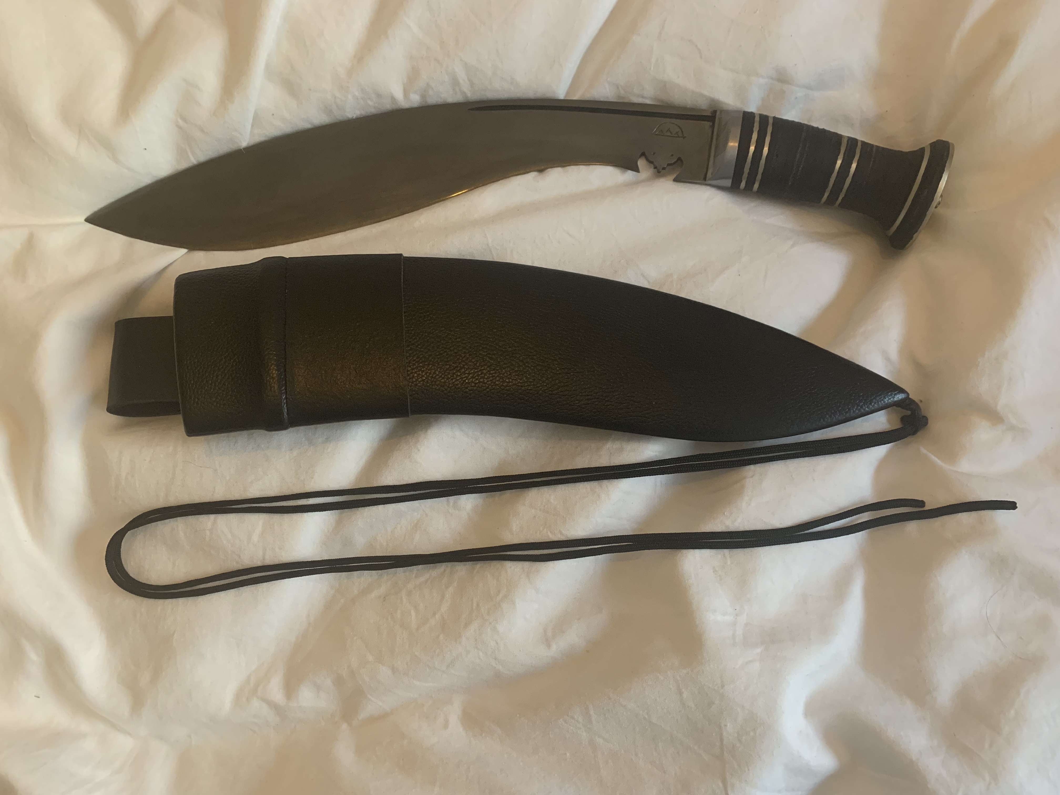
I’m not going to give a you a detailed history of the khukuri, there are many others out there with far more knowledge of the subject than I (not least KB themselves). Suffice it to say that KB has a wide range of both traditional and modern takes on this traditional, heavy Nepalese blade. I went with the Fort William Mk-1, which is based on the first standard military issue knife from 1903. I haven’t gone for it for the military heritage (because unearned glory) but for the shape, which I think is beautiful. The KB website lets you select from different blade and handle lengths, different sheaths, grinds, handle materials etc. All of their knives come in 5160 spring steel. It’s a real workhorse carbon steel but not stainless so you need to take responsibility for making sure it doesn’t rust.

Andrew at KB was really responsive and helpful with my enquiries about style and size of khukuri and the options available. He was also really proactive with communications about potential incoming issues with UK customs. And, once I’d received my monster, he had plenty of advice on sharpening this very distinctive blade style. I maintain all my own kitchen knives with a collection of whetstones but had no idea how to manage this thing on that setup (you actually don’t, you need honing rods).

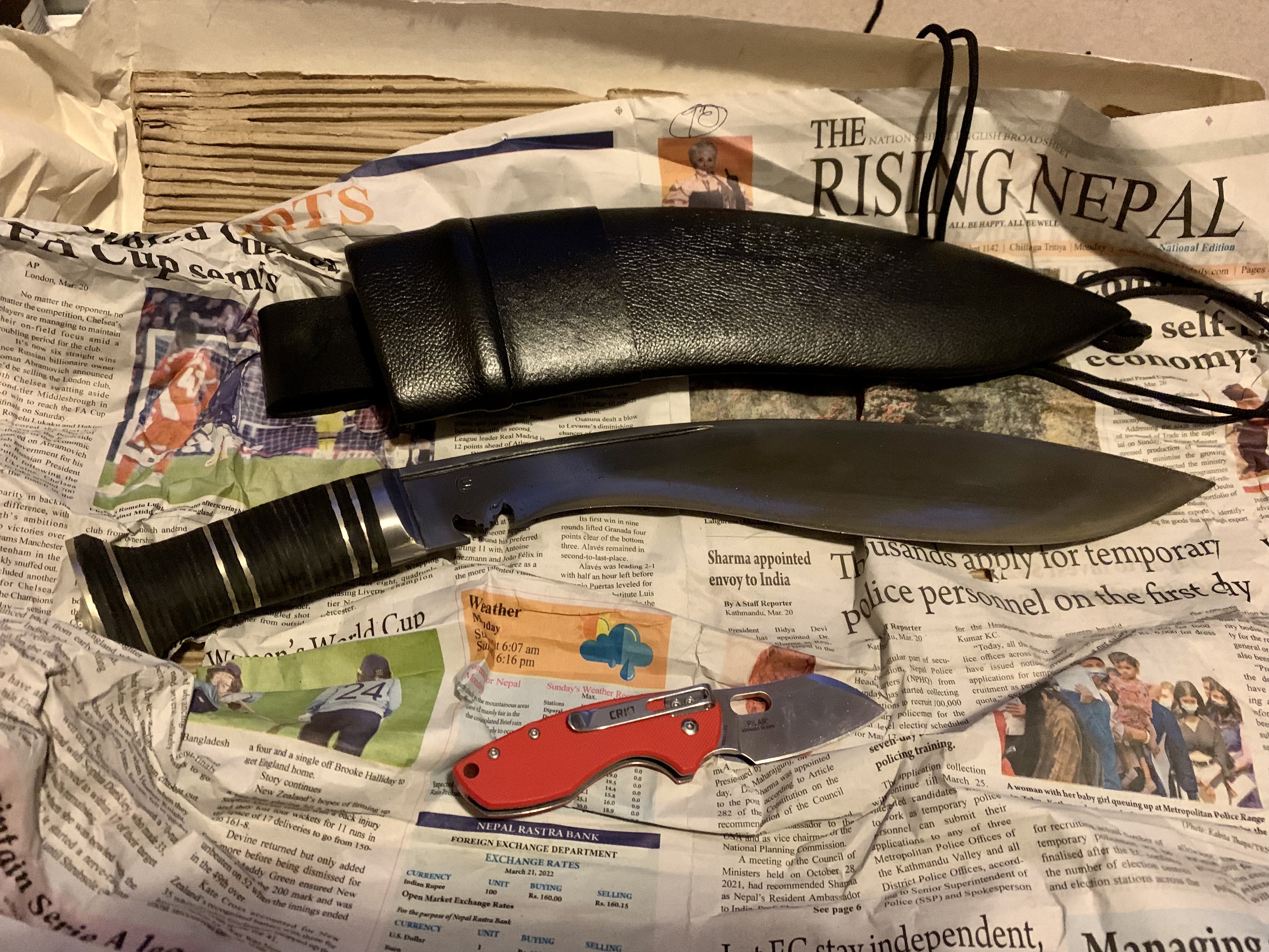
So, I went with a 13″ blade, a short handle (on Andrew’s advice) of stacked leather, traditional sheath and acid-wash finish. The finish is meant to bring out the hamon as these blades are differentially tempered so you get that distinctive line between the softer steel of the back and the hard steel of the edge. It’s very subtle; I could probably bring it out with a bit more polishing. If you’re hoping to see the kind of wavering line behind the edge that you’d get on, for instance, a tachi or a wakizashi, you’re going to be disappointed. This isn’t a criticism, it’s an observation. It’s like comparing geese and ducks – they’re related but they’re different. I’m not a big fan of two of the other finishes (polished and raw) and I think a satin finish will get battered quite quickly on a knife like this. Even if the hamon isn’t absolutely popping, I like the sort of dull (in a good way) colour of the blade and I think it will lend itself nicely to patination. These are personal, aesthetic choices, of course – I really like how the blade has turned out. (Andrew was good enough to respond to this and other points in this blog post – see the comments section below)

Spoiler alert: it looks like this. I’ve pre-empted the unboxing gallery but this post was looking really text-heavy and nobody cares about unboxing. This isn’t YouTube.

Customs problems overcome or anyway sidestepped, my khukuri arrived in early January. This was two months after ordering and the day before my sister’s birthday ( these facts are unrelated). It was extremely well (and protectively) packaged and sharp enough to shave the hairs off the back of my arm. To me, the short handle seemed just a little short and I started to fret I’d made the kind of mistake you can’t really rectify.

The traditional sheath (or dap) can be hung vertically or horizontally but the frog that attaches it to your belt cannot be rotated around to the other side of the sheath; I think it’s glued in place. If you’re left handed or want to try to wear it horizontally across your back, make sure you order a left-handed sheath (but see comments from Andrew). The thing across your back sounds cool but it’s movie cool, yeah? It looks cool when Deadpool does it but Deadpool has an editor and jump-cuts. You don’t and you’ll struggle to draw it and then spend the rest of your natural life trying to re-sheath it. Or you’ll cut your fingers off. I imagine if I’d enquired about a lace-up frog that also allowed for vertical/horizontal carry then it could have been had for a doubtless reasonable price.

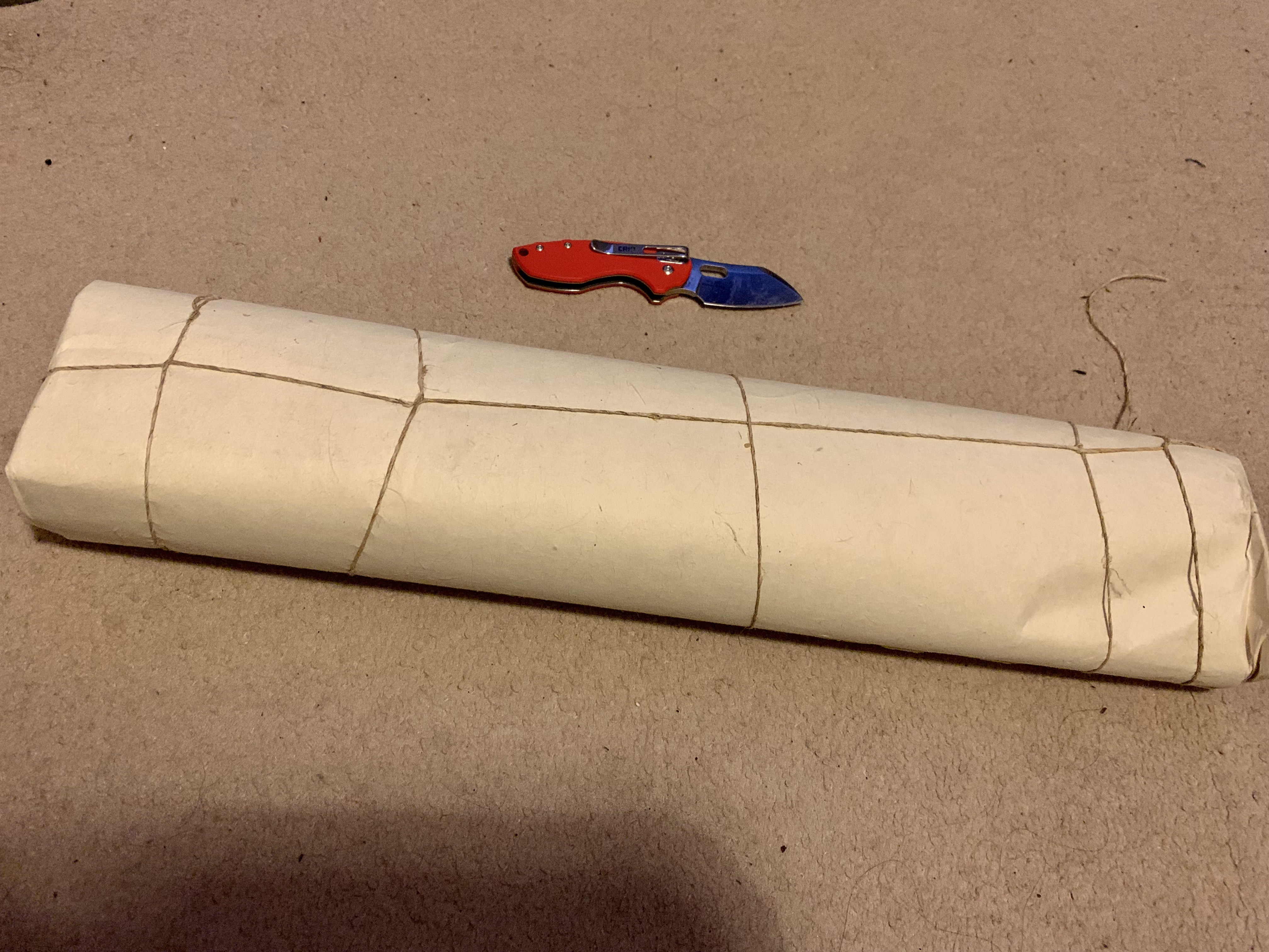
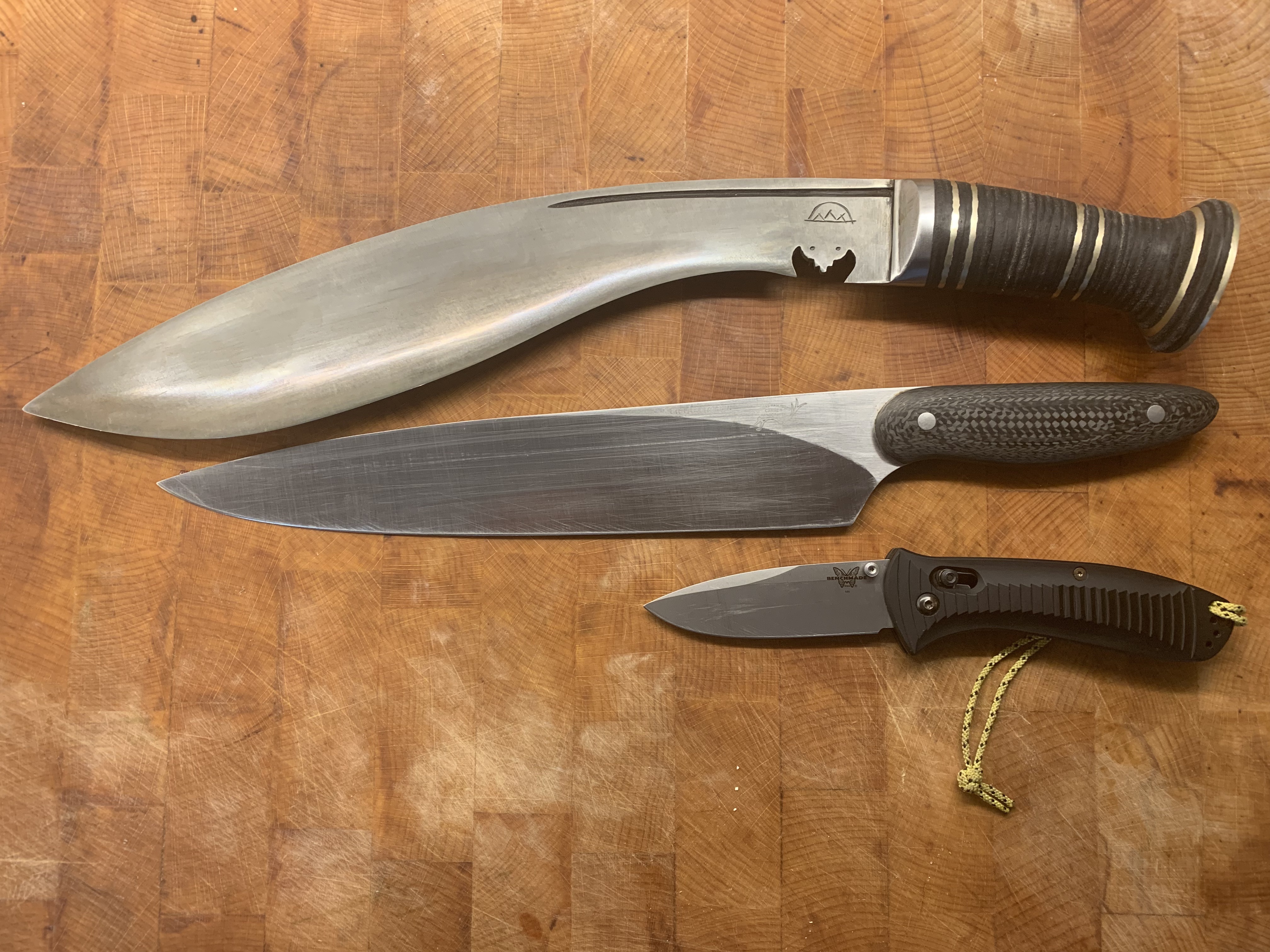
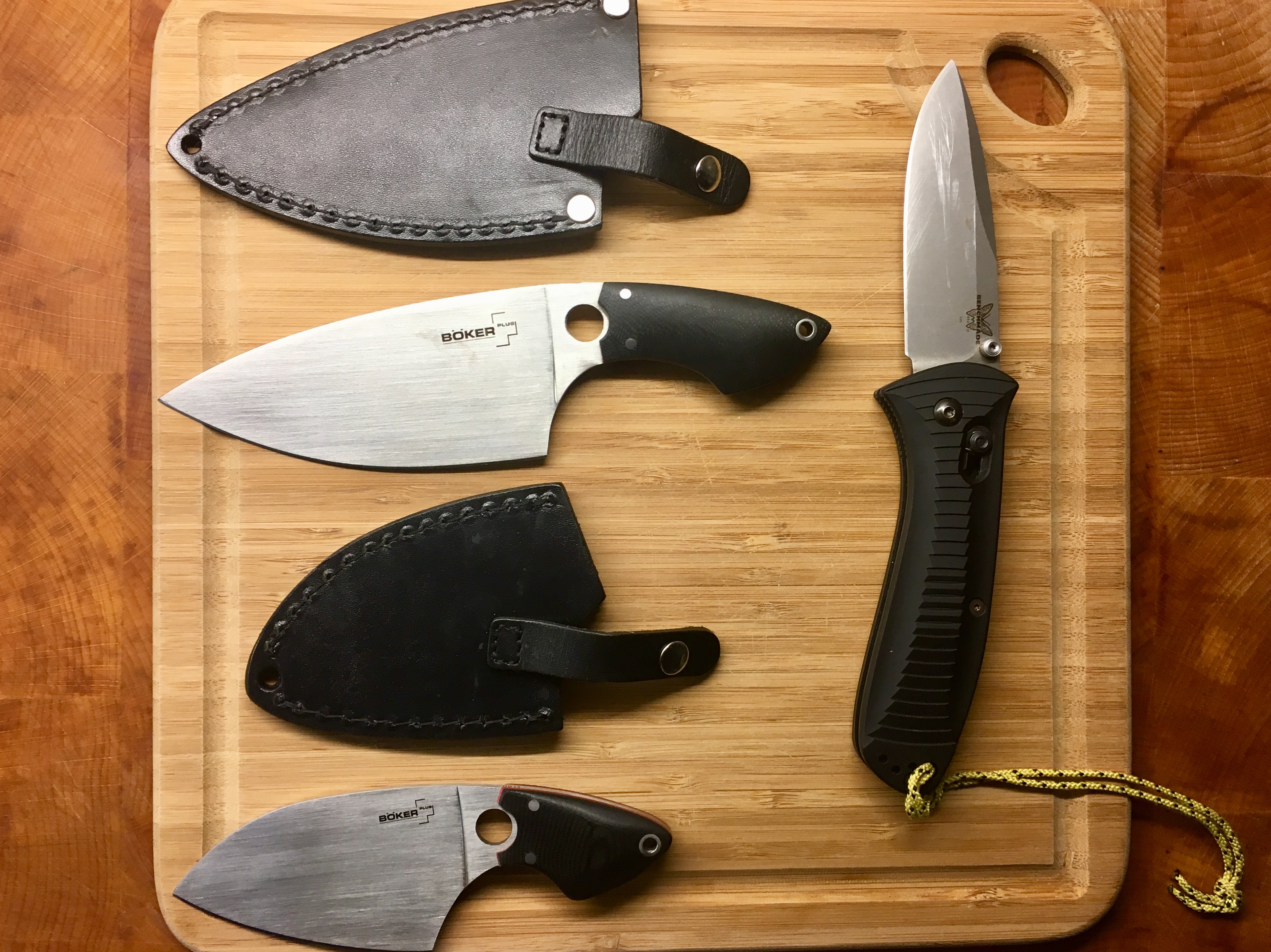
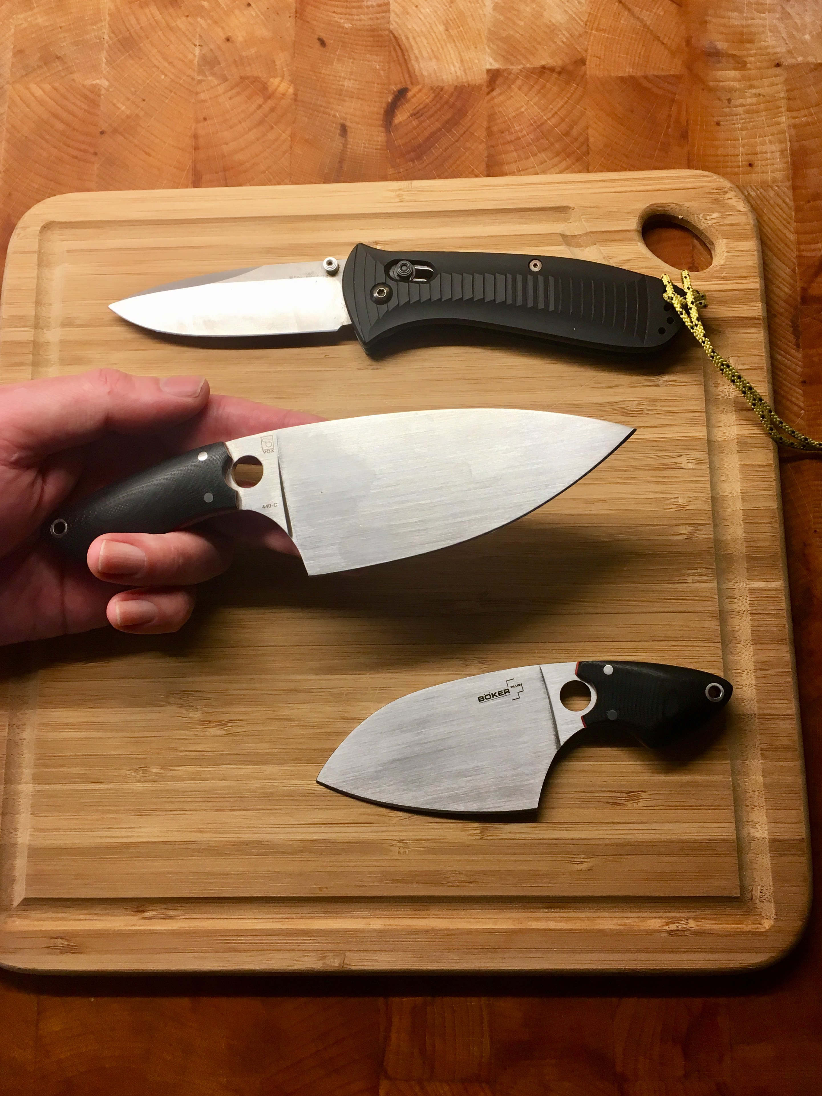
When you say a 13″ blade, it sounds massive and it is – there’s a picture below of it with a 10″ chef’s knife and big folder for comparison. In the hand, though, it doesn’t feel quite like the sword you might be imagining. It’s no EDC but the very weight-forward balance is deceptive, and it feels lively and surprisingly mobile. They’ve done something magical with the grind where it is hollow ground but then it swells back out to become a convex grind. This helps to keep the overall weight down but maintains mass immediately behind the edge to give some impact to your cuts.

Kailash Blades Fort William Mk-1 with Haslinger Custom New Generation 10″ chef’s knife and Benchmade Presidio for scale.

Its first job was some garden maintenance. I have an ivy hedge growing over the iron railings around my garden. Last year, I’d trimmed it off about a metre from the floor; it had grown back down and now tendrils were creeping across the decking. It sounds trivial but actually slicing through multiple, woody ropes of ivy at the same time is quite a tough little task. It was accomplished very quickly and without difficulty. That big, weighty fore-end with its curved edge just wants to cut. And once I was swinging it, the short handle suddenly made sense, it really pushed the balance of the blade into each cut. Andrew, I am sorry I ever doubted you.

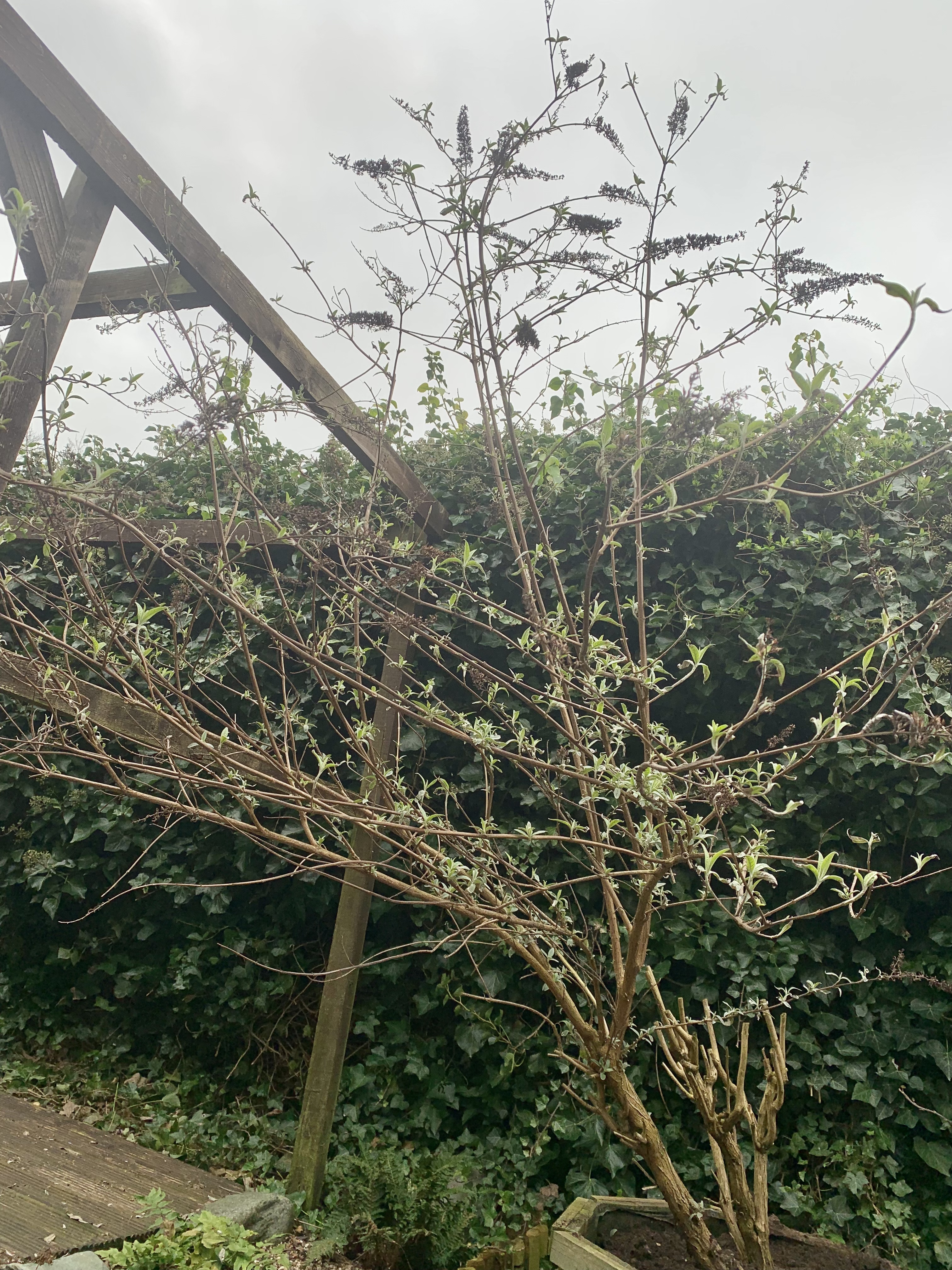
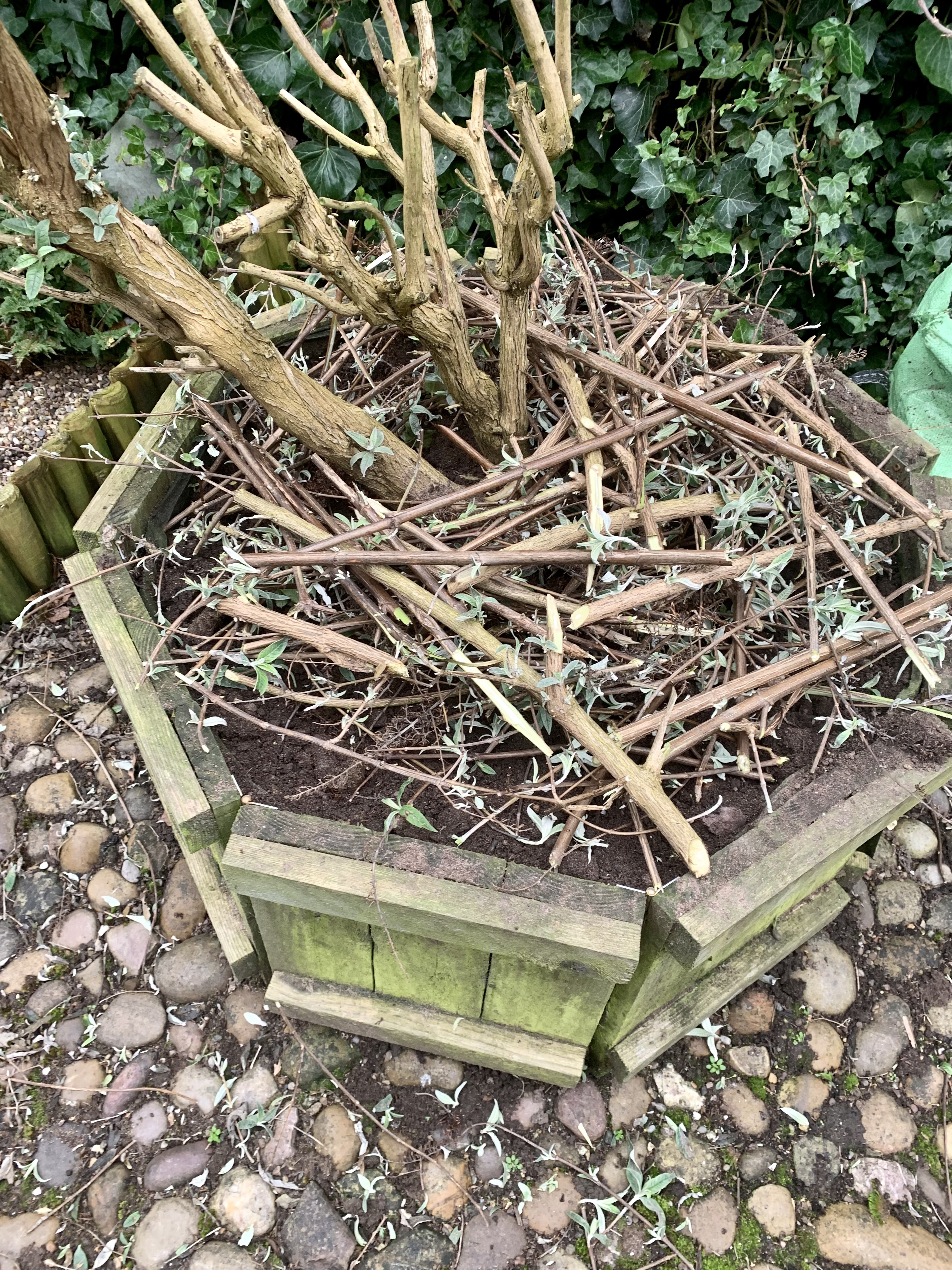
Next was pruning the buddleja, which had fallen off my winter to-do list because I got an X-box GamePass and Back 4 Blood was on there for free. Anyway, the buddleja was a much more lignified affair than the ivy, with some branches over an inch thick at the base. I went at it progressively to test the blade against thin, whippy limbs through to gradually stouter branches. In less than an hour, I had reduced the bush to something less than a foot high and then reduced the trimmed limbs to shorter lengths that I stacked in the planter to deter the neighbour’s cat from shitting in there. It’s not like buddleja is a crop but I just don’t want to garden around faeces.

During my exertions with the ivy, I had clumsily ploughed the end of the blade into the soil under the hedge. The edge itself had a couple of very minor rolls, which I polished out but I had also bent the very tip, presumably on stones in the soil. This is entirely my fault and not something for which I can fault the blade. I have since taught myself to reshape knife tips and, needless to say, I shall not be making that mistake again. It wasn’t actually as difficult as I had feared and maintaining this beast is actually pretty easy once you get over the hump of the blade shape (that’s a case of clamping it edge up and then running a set of progressively finer honing rods along either side until you have an edge with which you can cleave time itself).

On the kitchen side of things, It’s not had much to do yet although I did decant the carcass bag from the freezer to make some room and some stock. The khukuri absolutely demolished two chicken carcasses and then some rather more robust pork ribs. If there as a problem, it was mostly about having room to swing in my tiny kitchen without turning the overhead cabinets to matchwood.

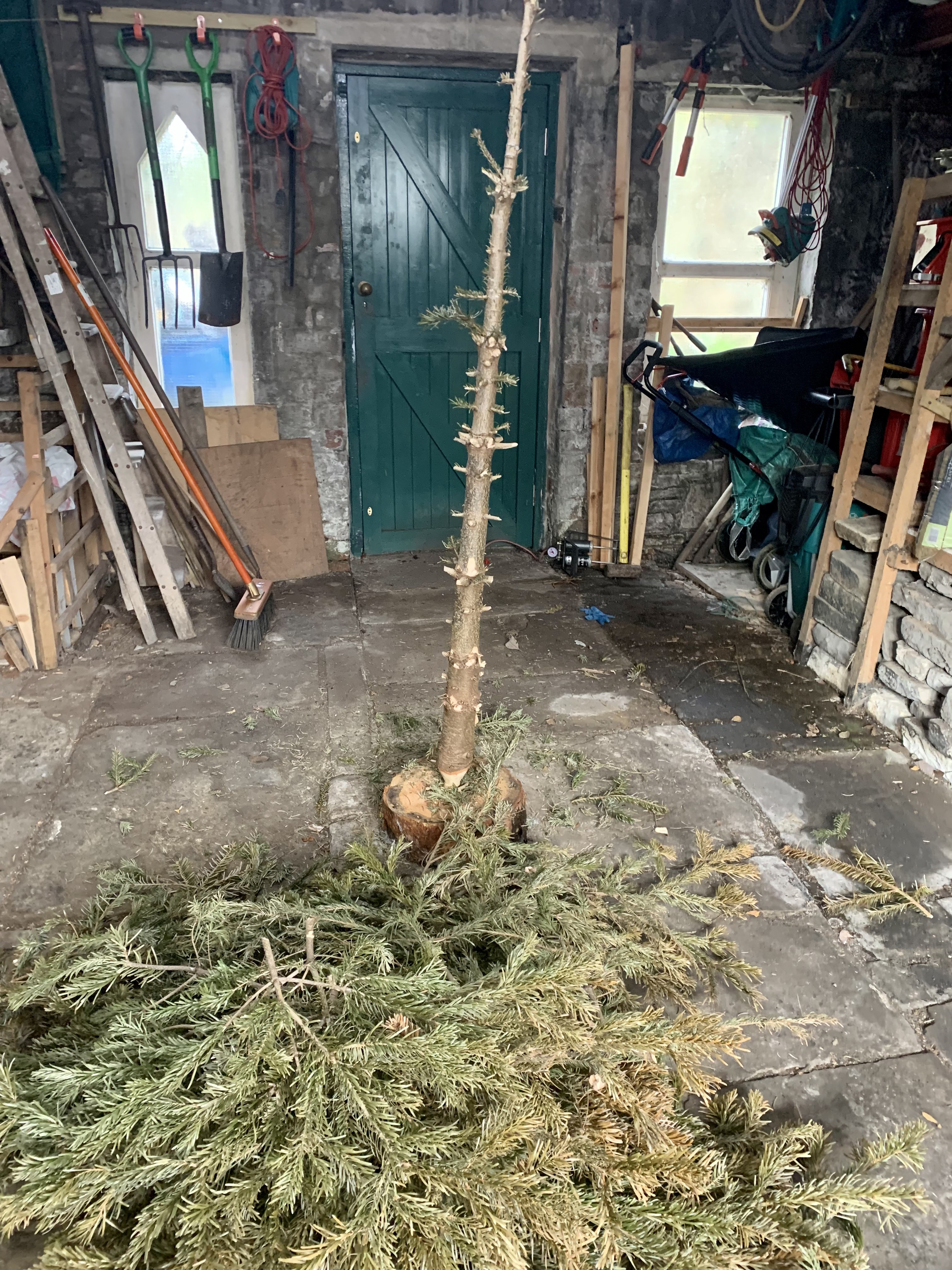
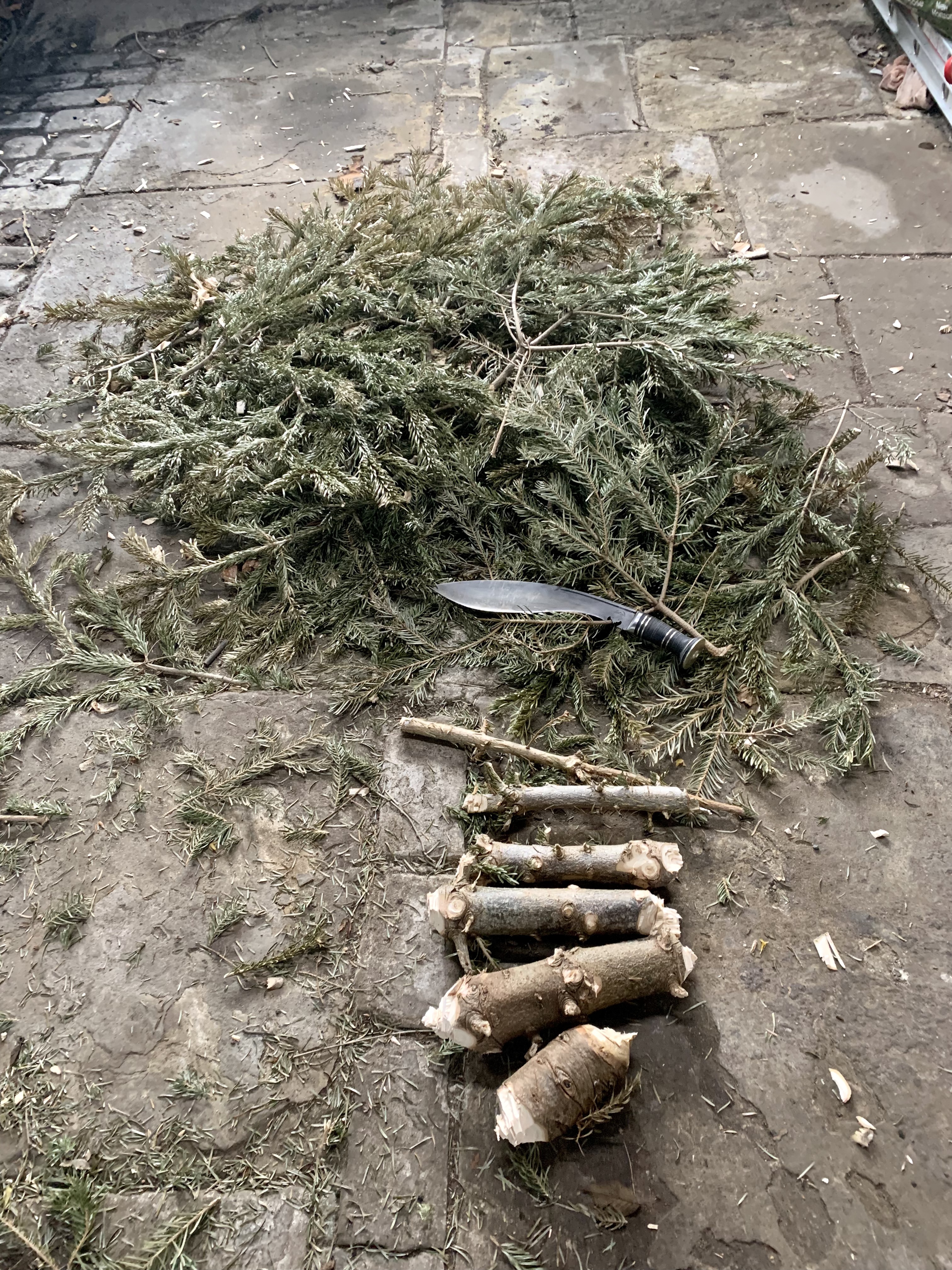
Most recently, while on holiday with my parents, my dad mentioned that their Christmas tree was still in the garage waiting to become firewood. I was home before them and popped round to theirs. I stripped off the limbs, cut them to fireplace length and then sectioned the trunk, all in in less than an hour.

Is there anything I’d change? Um, I don’t know. Although the handle feels good in use, it still looks weirdly short to my eye. But it does feel good in use so… And the metal washers in the stacked leather look sort of brassy, which clashes with the steel furniture? I daresay if I’d asked, I could have had steel washers. In fairness, they do look sort of brassy on the website but I didn’t think. It’s an incredibly minor quibble (but see comments from Andrew).

In summary, this is superb thing. Is the final fit and finish as tidy as some of the high end stuff out there? No, but it’s less than half the price of (for example) the Extreme Ratio Kukri Machette. While it may not have featured in Far Cry 4, it’s a really solid bit of kit; it’s handmade by just one blacksmith from start to finish; it’s an absolute joy to use; KB really supports its blacksmiths; the team there is really good to work with, communicative and open to customisation if you’ve ideas in that direction; and it will undoubtedly still be up for some hard work long after I am gone. Plus it’s going to get better looking as it gets older.

As I’ve noted in another post about knives, carrying a knife in the UK is legally context dependant – you need to have good reason to have one in public. If I were using this to, for instance, clear scrub on a nature reserve then I’m probably ok. If I’m carrying this in a city centre then I am definitely not and I’m probably also an arsehole. I should also add that I have no legal training so don’t rely on this general advice – make sure you do your research.

Wether Fell/Drumaldrace, 11/03/22, 21km, 5.5 hours

The hills:

Another one of these looming Wensleydale summits, though somewhat loftier than yesterday’s jaunt up Addlebrough. The massif itself appears on the OS map as Wether Fell but the summit (614m) has its own name: Drumaldrace. The meaning of Drumaldrace, as with Pen-y-ghent, is lost to antiquity and subject to conjecture. I will let you explore those theories yourself.

The route:

My accommodation is in Askrigg so that’s where I’m starting, but if you were coming to the Dales specifically for this then it would make sense to start from Bainbridge. As it is, I follow A684 from Askrigg to Bainbridge and then follow it across the bridge over the River Bain (see what they did there). Glancing to the right, I see a huge Archimedes screw leaning down across a short waterfall, presumably to generate electricity. Where the A684 bears around to the left, there is a smaller road running uphill and to the right, signposted Semer Water. I take a footpath here that handrails the road for about 300m. Where the road bends sharply uphill toward a mast of some kind, the footpath continues across rough pasture, following the course of the River Bain. This is gentle going over springy turf, oystercatchers calling to either signal their territory or warn of the terrible threat of me.

At some point (I think just after a little tributary joins it) the River Bain stops being the River Bain and is instead named Low Wheel. Just beyond is Semer Water Bridge and beyond that is, unsurprisingly, Semer Water. According to Yorkshire Wildlife Trust: “Semer Water is the largest of only three natural waterbodies in Yorkshire; a glacial lake which was formed at the end of the last Ice Age when huge amounts of glacial till blocked the outflow.” As its also the second largest natural lake in Yorkshire after Hornsea Mere, I suspect the web text needs updating. Maybe the largest in the Dales? To be honest, in this flat light and the buffeting wind, I am struggling to get excited about it (sorry, YWT – I’ll come back another day when I’m not on the clock).

Semer Water possibly not at its best.

To the right of the bridge, the road runs northwest and steeply uphill. It is strewn with light debris from the recent storms (but still entirely passable). I follow it to the tiny settlement of Countersett. There’s an odd, stretched out crossroads at which I keep heading uphill. At the first right-hand bend, there’s a path heading out left across pasture and I could then head uphill after about 400m. Instead, I stick with the steeper ascent of Crag Side Road until a very distinct right angle bend to the right. I’m moving much better than yesterday, pushing uphill smoothly and with fewer pauses. Also, I’m timing my pauses to coincide with letting cars past so nobody can tell I’m stopping to catch my breath. Except you, gentle reader. Here, I leave the road to follow a bridleway across the flank of the Wether Fell massif. As I’m about to pass through a second gate, I see a low hut with a corrugated metal roof, a flash of russet feathers and coxcomb. I’m thinking it’s a very strange place to keep chickens (I’m on the 410m contour) when I see a long tail vanishing and realise it is a male pheasant.

Looking back to Addlebrough from Crag Side Road

The bridleway climbs due west, gradually pulling up the flank of the hill. When I stop for water, I take the map from the kangaroo pouch of my smock (it is beaded with condensation from my sweat) thinking that I just have to follow this to the very obvious Roman road. I stick my gloves on (the wind is really cold) and set off, pausing only to admire the rather splendid view down to Semer Water and Raydale. I reach a fork and take the lefthand path, remembering that the bridleway contours under the summit for quite some distance. In 5 minutes, I realise I have gone wrong, dig out the map, get my bearings and put myself back on track. It costs me maybe 10 minutes. That’s not much of an issue but only because the visibility is very good. I should know better. You’ll make mistakes carrying and following the map too, but there’ll be fewer, easier to correct and not down to memory. the There’s an easy, family-friendly way to get things right: active navigation is accurate navigation, passive navigation is piss-poor.

The bridleway passes through a gate and onto a walled lane. To the left, it wiggles uphill round a contour. To the right it runs arrow straight almost all the way back to Bainbridge. I’m pretty confident this is a Roman road but the map confirms it. It’s a fairly hard surface covered in loose stones and, apart from its navigational ease, not an ideal descent. I have a cunning plan, though…

Turning uphill, I find a ewe and (presumably) last year’s lamb. They retreat before me, bleating at each other and the cosmos. This is a walled lane and there is nowhere for them to go. They carry on retreating before me for about 750m. Eventually we all hit a gate; I sidle round them, they bolt downhill and I pass through the gate with a sense of relief. Until I remember that they will still be in the walled lane when I come back and there is about 3km of it behind me.

The summit cairn, Addlebrough and Carlton Fell beyond.

Off to my left (south) I see the back of Fleet Moss, Darnbrook Fell, Pen-y-ghent. Further round, there is the summit of Ingleborough and then Whernside. To the north, the hills are buried under a mantle of cloud. In any case, I do not know this Dale very well at all and even in sunshine might struggle to recognise them.

I follow the road, glimpsing some sort of structure on the summit of the moor, until a path beckons me onwards and upwards. I am traipsing across blanket bog now and, sadly, someone on either a mountain bike or a trials bike has torn the Sphagnum capillifolium from the ground to leave it drying in the wind. I try to tuck back in safely while hoping that the miscreant’s next shit is a hairbrush. I take in the view, take some pictures, eat a cheese and HP sauce roll and then head off again. It is less windy than yesterday but I am considerably higher and wary of letting my muscles cool.

I pull the trekking poles from my pack, making sure the rubber tips are secure, set them to length and retrace my steps. As I join the road once more, my knees are straight away grateful for the support they get from the poles. Navigationally, I really just do have to point myself downhill and go in a straight line until I am in Bainbridge. As with navigation, it pays to be actively using the poles, pushing away at the ground to cushion your knees. Inevitably on this kind of surface, I get pebbles under my heel and turn my ankle. It happens less frequently, though, than without poles and is less painful when it does. Also my lats and triceps are getting a workout.

What have the Romans ever etc… Spoiler alert: this goes on for 5km this and this is as fun as it gets.

In the lane, only one of the sheep is still there – the ewe. Last year’s lamb has climbed through a gap between a hole in the wall and the bottom of the wire above. It is bleating through the whole at its mother and she is bleating back. I try to give her space so that I can get around her or she can get through. But she bolts, obviously, and last year’s lamb jumps back through and runs after her. Obviously. I sigh all the way down into my pelvic girdle.

After what seems like 15 minutes of exasperated exhalation, my eye is caught by a flash of colour. A goldfinch has appeared on the fence. That’s weird. I scrabble for my iPhone but it is gone before I can catch it. It’s not like I’ve never seen a goldfinch before but I’ve never seen one up over 500m.

Turning back to the Roman road and the escaped sheep, I start walking downhill. I’m not actually walking very quickly but I’m somehow covering a lot of ground. The road, or rather the verges on either side widen out and I finally get enough room to get past the bleaters and leave them behind. Up ahead, there is the unexpected sight of two 4x4s. I don’t know if they’re allowed on this byway (it turns out they are) but I can’t see that a confrontation will end well for me.

As they approach, a brown thrush-like shape flits down into the drainage ditch on the right. We’re a long way up for blackbirds but then I’ve just seen a goldfinch so who knows?

I step off the track and the vehicles edge courteously past, giving me a wave of thanks. My pastime almost killed me so I’m in no position to judge, but two blokes in separate vehicles driving up a track? Imagine the banter they’ll have! As I say, they have impeccable manners and are doing me no harm so each to each.

The brown shape pops back up and scoots over the drystone wall – a female ring ouzel! I haven’t seen one in years and am thoroughly pleased. Turning back to my journey, I walk down a Roman road for a geological epoch, legs and arms tiring, all of my many ventilation options gaping but still slightly too warm. The wrist loops on my poles are just slightly too tight and the wrong way out so the Cordura is starting the eat the skin off the back of my left hand, which is really stinging in the sweat.

The Roman road meets a modern road and then continues on the other side. As do I, for a further geological epoch, pausing only to adjust the straps on my poles. Finally, after almost 5km of ploughing in a straight line, the Roman road opens out on to another modern road that wriggles around the back of the National Park centre before dropping into Bainbridge. I sit on a bench, drink water, eat another cheese roll and then follow the River Are back to Askrigg.

Kit list:

In my pack (a Macpac Amp 25): Buffalo Belay jacket, Silva type 4/54 compass, OS OL Sheet 30, Benchmade Presidio lock-knife, iPhone, Veho Pebble phone-charger, half a litre of water, 2 cheese and HP sauce rolls (other brown sauces are avaialable), Terra Nova 2 person emergency shelter, Lifesytsems Trek first aid kit, Black Diamond ReVolt head torch, Julbo sunglasses, Zajo carbon trekking poles, some Lowe Alpine winter mountaineering gloves – they’re over 20 years old now and I don’t know what model. I wore my Montane Extreme smock, Montane Terra XT salopettes, Millet Super Trident GTX boots and Paramo Mountain gaiters.

Addlebrough, 09/03/22, 6km, 3.5 hours

The hills

Addlebrough is the peculiar plateau looming above the southern side of Wensleydale above Aysgarth Falls. At only 481m, it is by no means a giant but it’s clear separation from surrounding scenery and distinctive profile make it visible from almost any point in this part of the Dale. From the north, the summit crown is ringed with a crown of limestone crags. There are the remains of two Iron Age settlements around the flanks of the fell. There’s also a glacial eratic that, according to legend, got there during a boulder throwing argument between a giant and the devil. I don’t see any of this as I am hideously unfit and focussing on getting my knackered body back in the game for a longer walk tomorrow.

The route

From the little amenity carpark in the top of Thornton Rust, I ford West Beck. Downstream, I see two peculiar upright slabs protruding into the flow. It is sunny, though, I can hear the moorland birds calling, and I’m just setting off so I pay them no mind.

Spring is not quite sprung…

On the far side of the stream, a walled lane forks due south and due west; I take the southern fork, climbing gently around a tiny patch of enclosed woodland. This far north and this high up (around 300m) there are no leaves on the trees yet although there buds threatening spring on the hawthorn bushes. The lane continues south and then curves westward to escape the walls. The track makes a very definite “Go west” argument (bit without any kind of Village People cosplay) but the right of way lies to the south southwest, gently climbing across some semi-improved pasture before passing through a gate onto moorland.

All around is the upland song of spring. Lapwings row across the sky in their odd, twitching flight, peewitting for all they’re worth; oystercatchers pipe; skylarks trill their territory from hundreds of metres up; curlews… um… curl? However you describe the individual calls, the moorland is in glorious chorus.

This is easy going across gentle slopes, the track obvious and only boggy in places. In one deep puddle I see a telltale puff of sediment under the surface. Peering in closer, there is a female common frog concealing herself in the sediment. She is definitely concealed from the view of predators but if the farmer comes along in tractor or quad, she will be a pancake. I consider trying to move her, but that would only expose her to predation so I let her be.

Here and there, around the edges of flushes, I have reminders of the day-job; Sphagnum is growing where conditions are wet enough – I think possibly fallax, but I’m on a mission, don’t have a hand lens, and my ID skills are questionable. Instead, I continue the gradual SSW ascent toward the 380m contour where the bridleway meets the wall I’ve been roughly following.

The track starts to handrail the wall closely but I cross over and start to handrail a wall north northwest, passing a 392m spot height on my right. Just beyond the end of the wall, there’s a way marker and an obvious path pushing straight upslope. Oh, God, I’m unfit. It’s quite steep, climbing 70m over a distance of 240m, but it’s not that steep. I pant and gasp my way to the top, pausing every 10 meters or so to curse the gradient and my lungs. The path eventually contours around to the south, slackening off on the ascent and I emerge onto the summit plateau. It is clear and bright and there is quite the view but the wind is fearsome; although not strong enough to buffet me, it’s a constant pressure and bitingly cold. There’s a rather nifty little cairn/seat where I pause briefly for a drink and pictures before retracing my route back down to Thornton Rust Moor.

Peculiar cairn/seat combo with (I think) Carlton Moor in the distance.

At the foot of the plateau, I consider retracing my route back along the bridleway and opt, instead, to boldly head out across the rough terrain before me. I’m reasonably certain I clocked some gates in the fence along the bottom of the moor (which is CRoW Access land) and head out on a bearing of roughly 330°. This is slightly boggy ground; there are flushes surrounded by cottongrass, clumps of deer and purple moor grass and, encouragingly, hummocks of Sphagnum – mostly wine red capillifoilium. Though wet and uneven, this is easy going underfoot and I spend most of this leg of the journey trying to remember the Sphagnum species that’s a bit like papillosum, starts with a p but is pointy rather than chunky. So that’s a brilliant holiday (it’s palustre, fyi).

Following the walled lane back down into Thornton Rust.

Where the (fairly new) wire fence meets the drystone wall, there’s a gate perhaps 10 metres from the junction. On the far side, I handrail the wall, dropping down through a little trough, up again and then down to very obvious track running through another gate. The bottom hinge has gone and I’m very careful opening and closing it. The track takes me back to join the bridleway where it drops into the walled lane and soon I am back at the carpark. I sit on a bench next to West Beck, drink some water, message Susan to let her know I am safe, and then have a peer at an interpretation panel. It explains the apparently famous Thornton West sheepfold. I’ve just lifted the following from this website:

The sheep dip is believed to have been originally set up after the Enclosure Act 1873 for the tenant farmers of Thornton Rust Hall, the Lords of the Manor.

The fold had two functions

  1. The sheep dip

The dip is made up of three parts. The first is the water boiling pots, the second the dip bath and the third the draining area and drip collection tank.

The process was as follows: The two large cast iron pots located over two small fire grates were filled with clear water the night before dipping. The fires were lit and lef to heat the water overnight. Originally the pots had a tin roof and chimney over them but they are now lost.

The following day a mixture of proprietary chemicals was cut from a large block, placed in a bucket and hot water was added. The mixture was stirred and then poured into the sheep dip bath which had been partly filled with stream water from the adjacent beck. The stream was blocked with turf to fill a small trough which remains in situ today. From the trough an underground pipe led to the dip bath.

Sheep were led into the enclosure adjacent to the dip and then led singly into the dip bath. A man stood in a manhole recess to the side of the bath to push the sheep under the surface. The sheep then left the bath to a third enclosure where they dripped surplus water back into a shallow collection tank which fed back to the main dip bath. After dripping the sheep were released out into what is now the car park area and led away.

A small fee was paid per head of sheep dipped and administered by the secretary of the dipping fund. Monies raised were used to maintain the structure and pay for consumables.

Around 15 farmers used the facility in its heyday.

  1. The sheep wash and clipping area.

This was a separate exercise and was undertaken to wash out lanolin and ticks (and salve) from the fleeces before clipping. The stream was blocked at the lower end of the sheep dip site by insserting a wooden slab between the two large stone slabs set in the stream and still in situ today. This created a large pool into which the sheep were driven and individually washed.

This practice stopped in the early 1900s. One reason was that the wool processors realised that lanolin was a valuable product which they preferred to be left in the fleeces to process themselves.

The sheepfold remained in use until the 1970s when it was largely abandoned. It is still used occasionally as a clipping and dosing area.

Kit list:

In my pack (a Macpac Amp 25): Buffalo Belay jacket, Silva type 4/54 compass, OS OL Sheet 30, Benchmade Presidio lock-knife, iPhone, Veho Pebble phone-charger, half a litre of water, Terra Nova 2 person emergency shelter, Lifesytsems Trek first aid kit, Black Diamond ReVolt head torch, Julbo sunglasses, Zajo carbon trekking poles, some Lowe Alpine winter mountaineering gloves – they’re over 20 years old now and I don’t know what model. I wore a Montane Extreme smock, Montane Terra XT salopettes, Millet Super Trident GTX boots and Paramo Mountain gaiters.

Pen-y-ghent Gill loop, Littondale, 07/08/19, 11.2km

The hills

This route doesn’t go over any tops – it squeezes around one of the upper branches of Littondale under the flanks of Fountains Fell and Pen-y-ghent. It’s pretty easy going although at this time of year, the heavy bracken on the latter half is a considerable trip hazard.

The route

Susan and I park (considerately) in Litton and head due west through the village. We see a sign on the left saying that this track gives no public access to the footbridge. We don’t take this track, but the next one, which draws us down to a footbridge over the River Skirfare. After the recent rainfall, it is in full flow, beer-dark with peat. When we were here a couple of months ago, it was bone dry. On the far side, we follow the path west and then southwest across some pasture to a little set of steps up onto a walled track.

68DD0470-12D8-471C-85E7-BEB9235C6992

Looking back to Litton from the flank of Darnbrook Fell.

The track heads northwest to the confusingly named New (it isn’t) Bridge – it was probably new when it was…um…new? We do no recross the Skirfare here as that would have made everything up to this point a wast of time. Going through a gate, the track heads uphill. The verges on either side are rich with clover and some kind of bedstraw, buzzing with insects.

The track levels out at around 400 metres, the wall on our left pretty constant, and somewhat intermittent to our right. Beyond that wall, Pen-y-ghent Gill carves a deep ravine down through the limestone. Above us, loom the shoulders of Darnbrook Fell and Fountains Fell, notched and hagged by erosion; the bare peat on those summits stains the streams that cut across our path. Most of the streams can simply be stepped over, and the wider ones have stepping stones. A lesser black-backed gull floats over us with a desiccated rabbit carcass clutched in its feet. It’s weird because I’ve never seen a gull carry anything in its feet before.

The track passes through a gate; you could follow it until it meets the road and then turn sharp right. Instead, we turn right immediately and handrail the fence north north west until it meets the road at an old field barn. We turn northeast past some slightly knackered looking limestone pavement, through a little gate and then pause for lunch just under the road bridge. This is actually more lovely than it sounds – it’s a tiny road and the bridge is over the uppermost stretches of Pen-y-ghent Gill; below us, the water swirls and gurgles; the limestone is whorled and smoothed by water; wild thyme and tiny ferns cling to crevices in the rock.

EFB5EA3E-6EA3-4546-ACB6-1FF1AD0FD0A4

Some wild thyme, some tiny ferns and some feet…

Crossing the gill, the path continues north east, dipping under a farmhouse and past a limestone cave (or murder-hole, according to S) and skims along around the 360 metre contour. Sheep have been fenced out of this part of the fell and there’s consequently a bit more vegetation. Botany is not, as you may have gathered, my strong suit, but there’s more bedstraw, harebells, clover and (I think) eyebright. We cross what would be a stream and possibly a waterfall in the winter, willow trees and rowan trees (in berry but not yet ripe) either side.

Beyond, the slope is cloaked in bracken, shoulder-high in places. We cannot see the path through the foliage and must move slowly and carefully lest our feet find some pocket in the ground that sends us scudding down the valley-side. Eventually, we are free of the clinging green and making a mental note to check ourselves for ticks when we get home. The path tilts upwards and we are soon up on the road that runs between Littondale and Silverdale. Pen-y-ghent broods on the horizon behind us – even in bright sunshine, that’s a brooding fell – Littondale beckons ahead.

5C106BC3-8ED1-4103-856D-5BC70AE479CB

Looking back up the valley to Pen-y-ghent.

In just over 100 metres, we drop back off the road and handrail a fence due east, under some sheep-dotted limestone pavement. On the other side of the gorge, a flotilla of cows of cruises through steep pasture in search of forage. We are gradually descending to the valley floor, dropping through a neat little group of cottages at Nether Heselden, where we recross the gill on a little footbridge. We handrail Pen-y-ghent Gill for perhaps 400 metres here until the path veers off southeast to New Bridge. From here, we retrace our steps to Litton.

Kit list:

In my pack (a Macpac Amp 25): Rab Demand pullover, Rab Bergan pants, Klättermusen Vidblåin smock,   Montane Flux belay jacket, Silva mirror-sighting compass, OS OL Sheet 4, Benchmade Presidio lock-knife, Highgear AltiTech 2 altimeter, iPhone, Veho Pebble phone-charger, two litres of water, a chicken and mushroom pasty, Terra Nova 2 person emergency shelter, Black Diamond ReVolt head torch. I wore Montane Terra trousers, some Clavin Klein microfibre base layer Mountain Hardwear Canyon shirt, Julbo sunglasses and Scarpa Rebel Lite GTX boots.

Grasmoor, 15/05/19, 9.6km, 3.5hrs

The hills

fullsizeoutput_855

Mountain weather forecast for the Lake District

Grasmoor (852m) is a huge old lump, the highest of the peaks in the group of summits between Coledale and Crummock Water. You can’t really see it approaching from the north, but from the south, it is inescapable.

The route

From the carpark at Lanthwaite Green Farm, I follow the road south – there’s plenty of room to get off the tarmac on the left side of the road. There are a further 2 carparks about 15 minutes walk; after the 2nd, I turn due east along Cinderdale Beck. I have a bit of a map reading dither here and nearly turn east to soon, which would take me up into Red Gill. There is no water in Red Gill. Just scree. Red scree. Now, I like a steep ascent as much as the next man (unless the next man is Heinrich Harrer) but 400m of scree is nobody’s idea of good way up.

The gradient is gentle at the start, but up ahead, I can see the going gets hard pretty quickly. The heat is a physical pressure today, pushing me down into the ground like a tack. I soak my hat in the beck and replace it, deliciously cold, on my head. Despite bing cotton, it is dry in 15 minutes.

The path follows Lad Hows, a great, steep ridge that curves round to the north. I meet a couple who have paused to get their breath. Their dog comes to say hello. And by “say hello”, I mean sniff my crotch. Revived by this inspection, I push myself onwards and upwards, making bargains with myself – you can stop for a breather when you get to that rock etc. I stop and take off my pack at the 550m contour, where the gradient goes up another gear. I drink water, eat flapjack, reconsider my predilection for steep ascents. Somewhere below, there is a high keening; a buzzard turns in slow, heavy circles around the foot of Low Bank.

4670A2DD-EA65-41E6-9799-48F7D9FC372D

The view back down Lad Hows to Crummock Water.

I turn back to the problem at hand. This is the steepest section of the day, the heat is really quite something else and the path is slippery with gravel. Resilience, perseverance and foul language see me cresting out onto the vast flat deck of Grasmoor’s summit.

There is a refreshing breeze up here and I make my way to the summit shelter with all the jauntiness I can muster. The summit shelter does exactly what it says on the tin and is consequently full of insects sheltering from the refreshing breeze. I make my excuses and leave.

Elsewhere on the plateau, I sit down and drink all of my coffee. Out to sea, you can see the Isle of Man on a clear day; a haze obscures the view today. Inland, however, I can see Red Pike, High Stile, High Crag, Pillar, Great Gable Green Gable, the Scafell massif, and there, away to the south, Harrison Stickle. To the north, my intended next fells of the day, Hopegill Head and Whiteside. Wearily, I clamber up and head east to the pass between Eel Crag (or Crag Hill, depending on whether you’re AWS or the OS). Thence I trudge roughly north into Coledale Hause, pausing only to soak my hat in the stream.

Coledale Hause is a meeting of many trails – Grasmoor, Eel Crag, Hopegill Head, Grisedale Pike all deposit walkers here. It is broad and flat and, in the weather, something of a heat trap. I sit and eat sandwiches and drink water and look at the next ascent – Sand Hill leading up onto Hopegill Head. Northwest of me, Gasgill Crags loom forebodingly under the summit of Whiteside. And I’m tired – Lad Hows really drained the joy out of me – and it’s hot and I don’t have enough water with me and I know I’m stubborn enough to finish this but not sure I’m fit enough to finish it safely. And nine times out of ten, I could finish it safely but these days I tend to dwell on that one time out of ten. Those fells will still be there another day so I head east, down beside Liza Beck.

It’s beautiful, actually, really lovely, the sound of water bubbling over little falls and birdsong echoing across the ravine. The path is a nightmare, mind – steep, slippery with loose stone; in places it’s just a horizontal shelf across scree. It’s like having a pet hyaena – it’s all banter until you stop concentrating on it and then it eats your legs. A hwee-tsak-tsak draws my attention to the heather slopes above me. I stop (tether the hyaena, step away from its jaws) and look to find a female stonechat scalding me. Turning back to the descent, I soak my hat once more and continue downwards. The beck winds round southwest and the tracks follows, sometimes skirting up the slope over a small crag, sometimes sticking close by the water. I never feel anywhere terribly exposed, but there are sections where a slip could be serious. You wouldn’t have to fall very far to knock yourself unconscious and unconscious in a stream is always a bad combination.

fullsizeoutput_850

Looking back up to Grasmoor from Liz Beck.

Finally, the ravine broadens out and I see Crummock Water glittering in the distance. I cross Liza Beck on a (really very sturdy) footbridge and head across some rough pasture to the carpark.

Some learning points from this:

  • be realistic about your fitness levels, especially on unfamiliar routes – I’ve done Grasmoor before but always from the easy side;
  • perhaps going at it from the other direction would have been easier – I’ve been up Whiteside from Lanthwaite before and it’s not as steep as Lad Hows;
  • carry more water on days like this – I looked at the forecast and still didn’t have enough with me;
  • I made the right decision to bail out.

Kit list:

In my pack (a Macpac Amp 25): Rab Demand pullover, Rab Bergan pants, Klättermusen Vidblåin smock,   Montane Flux belay jacket, Silva mirror-sighting compass, OS OL Sheet 4, Benchmade Presidio lock-knife, Highgear AltiTech 2 altimeter, iPhone, Veho Pebble phone-charger, half a litre of water, decaf coffee, sandwiches, flapjack, Terra Nova 2 person emergency shelter, Black Diamond ReVolt head torch. I wore some Marmot shorts designed by Tommy Caldwell, some Clavin Klein microfibre base layer Mountain Hardwear Canyon shirt, a cap by Blurr, Julbo sunglasses and Millet Super Trident GTX boots.

Causey Pike, 14/05/19, 9.8km, 3hrs

The hill

Causey Pike (637m) is an imposing prow, with its mad cockscomb ridge visible from the A66 more or less once you get past Threlkeld, heading west.


fullsizeoutput_841

Causey Pike summit peering at me down in Stonycroft Gill.

The walk

From the village shop (it’s a splendid shop by the way), I head due south out of Braithwaite and leave the road where a broad track leads up to Braithwaite Lodge and the foot of Barrow. House martins skim above the pasture around the lodge and a skylark is bickering (can you bicker on your own?) over the dried bracken carpeting the foot of Barrow. I skirt around the eastern flank of the ridge; a garden warbler trills in the woodland to my left. Spring is doing its thing as summer hovers in the wings.

The path drops me back onto the road beyond the woodland, gorse filling the air with its exotic coconut perfume. As I follow the road south, I hear a soft klonk klonk above. I look up to find the raven, turning lazy circles above Barrow. Beyond and to the south, I can see a couple stationary on the side of Causey Pike.

The road takes me over an absolute shortbread tin of a stone bridge. Looking west, Stonycroft Gill winds up into the tops flanked by gorse. The couple have not moved since I first saw them. As I start to ascend, I see they have stopped where the path separates – they can either push steeply up Rowling End, past the Lone Tree of Causey Pike, or they can take the more gradual ascent that draws you up under the ridge to Sleet Hause.

They choose the former (as I already have – I like a steep ascent and a gradual descent) and I sit on a rock and drink water. I have not hydrated properly after last night’s drinks, it is really very sunny, pretty steep, and I am unfit.

fullsizeoutput_842

The Lone Tree of Causey Pike.

I set off again up the side and then moving ’round to the prow of Rowling End. There are some short sections where I must use my hands to get over some step or other in the rock. It is altogether more pleasant than the my last excursion on this mountain. There are clumps of Sphagnum, too desiccated for my ID skills (I only recognise about 3), heather, bilberry. I pass the couple – they are older than I – is this a reverse Gandalfing? Legolasing? They step back to let me past and we exchange friendly small talk about the route. I am soon pulling past the Lone Tree of Causey Pike (unlike my last visit, it has leaves now and is definitely a rowan) and up onto the ridge.

The walk along the ridge is like an aircraft carrier deck, albeit an undulating one covered in heather. The bilberry up here is in fruit (I assume because the plants get more sunlight) though they are pink and unripe. A gentle breeze keeps the insects down as I make my way toward the summit ridge. Somewhere down in Newlands Valley, there is a cuckoo calling; ahead, I see a raven drift over the summit.

The main summit ridge looks a beast from the far end of Rowling End, but up close, it’s really not that bad. I stop for more water and some chocolate. My chocolate bar has been in the lid pocket of my rucksack and, once unwrapped, is a hot (admittedly tasty) turd.

There is a klonk immediately overhead. The raven, gliding above me, has its wings cocked back flanking its wedge shaped tail. For a shining moment, silhouetted against the bright sky, it is the head of Gungnir, Odin’s spear, dedicating the fallen to old one-eye. I’ve definitely not read too much Norse mythology, no.

I start to pick my way up the ridge, pausing frequently for breath. Some species of wood wasp lands briefly at my feet, her ovipositor a bright needle in the sun. Fun wasp fact: only female wasps (or bees or ants) can sting because the sting is a modified ovipositor. Pushing through my breathlessness, I force myself to keep going to try to build some level of fitness. The last 10 metres of so require the use of hands. Even AWS wouldn’t call this a scramble but it feels good to be using climbing wall skills (I started again in December) in the real world. At the top, I pause again for more water and to take in the view. I can see all of the Newlands and Coledale horseshoes, Great Gable, Green Gable, Helvellyn, Skiddaw, Blencathra, Haystacks and the ridge that runs along from there above Buttermere. It really is splendid.

Making my way across the nobbles toward Scar Crags, I’m climbing once more, but so gently that it’s not apparent. I have timed my walk so as to be on the summit in the hottest part of the day. Obviously, this is idiocy, but it makes my next decision for me. Rather than walking the length of the Crags and then descending through Sail Pass, I drop off the north flank of the hill before; a sheep track leads me under Scar Crags and down to High Moss, just under Outerside. On the summit there is either someone dressed entirely in red or a postbox.

The path leading due northeast here is one of my least favourite paths in the Lake District. It’s navigationally very easy, but it’s basically a trough full of rubble so if you’re an organism with ankles and/or knees, it is a misery. I take the first sheep track on the left, which loops me around the worst of the builders’ aggregate, and then I take another track running east(ish) into Barrow Door. The first time I came here, aged 16, I spent ages  looking for an actual door in an actual barrow. As you may have gathered, Tolkien has cast a long shadow across my life.

fullsizeoutput_848

The cockscomb summit of Causey Pike from Barrow Door.

Slipping between Stile End and Barrow, I start the final stage of my descent back towards Braithwaite. I Legolas (see) another older couple. They are each wearing what looks like about 4 layers. It is 23°C. They smile at me, but do not look happy. The path takes me northeast back to tarmac.

On the far side of Barrow Gill, I can see a woman cross over into sheep pasture with two dogs, neither of which are on leads. One of them, a Jack Russel, immediately starts chasing lambs. The woman is shouting at it and chasing it, but it is not interested in her. I am too far away to intervene, but if you own the first bit of pasture east of Barrow Gill and south of Barrow and your sheep have been attacked, the dog was called Muffle or Buffle or such and its owner is a light-haired woman in a pink top. If you are the owner, please keep your dogs on leads around livestock.

As I do through the gate back onto tarmac, a couple from the South West ask me if the wasps have gone. I look baffled and they point to a gorse bush behind me and explain that when they tried to go up that way, they were prevented by a cloud of wasps or bees. I can tell them only that I have been unimpeded by insects. we exchange pleasantries about the weather and then I am back at the village shop.

fullsizeoutput_832

Mountain weather forecast for the Lake District

Kit list:

In my pack (a Macpac Amp 25): Rab Demand pullover, Rab Bergan pants, Klättermusen Vidblåin smock,   Montane Flux belay jacket, Silva mirror-sighting compass (stupidly, I left my map in the kitchen, but I know the route and the visibility was endless0, Benchmade Presidio lock-knife, Highgear AltiTech 2 altimeter, iPhone, Veho Pebble phone-charger, half a litre of water, a Bounty (no, dark chocolate – I’m not a savage), Terra Nova 2 person emergency shelter, Black Diamond ReVolt head torch. I wore some Marmot shorts designed by Tommy Caldwell, some Clavin Klein microfibre base layer Mountain Hardwear Canyon shirt, a cap by Blurr, Julbo sunglasses and Millet Super Trident GTX boots.

Böker Plus ChefYouGo and SanYouGo, 11/09/18

I’d been hunting around for a practical chef’s knife to take camping (for those camps where I’m not rehydrating a food pouch) or perhaps just  on holiday in self catering accommodation. Ideally, it would have a sheather so that I can just lobby it into my luggage without wrapping it up to protect the edge or the luggage.

The Böker Field Butcher,  designed by Jesper Voxnæs, is a splendid looking beast – top end steel, premium leather sheath, the blade is 4mm thick so probably up to feathering kindling and the like – but it’s £200 and I just can’t justify that for holiday cutlery. As it happens, Böker has a value brand (if you will), Böker Plus, which has some interesting and more reasonably priced offerings…

The ChefYouGo and SanYouGo are also designed by Jesper Voxnæs. They both come with sheaths, in rather nice presentation boxes. I had to go through a lot of YouTube footage to find actual reviews before deciding on them. (For. the. love. of. God, YouTubers, an unboxing video is not a review. Caption your content properly, you savages.) I picked the pair of them up for £106.86 and I’ve just come back from a week’s self catering holiday; can you guess what happens next? Yes, an unboxing video.

They’re both made from 440C stainless steel, tempered to a Rockwell hardness of HRC 57-58. I’m not a metallurgist, but that’s not too shabby. The Rockwell scale tests hardness by pressing a diamond into the steel and measuring resistance to that pressure (it’s a bit more complicated, I think, but as we’ve just observed, I’m not a metallurgist).  For comparison, Wüsthof knives clock in at 56-58, the Field Butcher at 58-60, my Haslinger New Generation at 61.

The scales (the grippy bits on the hilt) are black G10, with red liners, and the sheaths are black leather. There are lanyard holes in the hilts, though I’d be dubious about lanyards trailing through, for instance, raw meat. The sheaths are nothing to get excited about, to be honest, but they do what they’re supposed to. The sheaths’ clasps catch on the knives’ choils unless you hold them clear whilst drawing. There’s also no means of attaching either sheath to a belt. I’ve no issue with that; I don’t want to carry a chef’s knife on my hip (see legal note at the end). You can find the dimensions for the blades and hilts in the links above. I’ve put my Benchmade Presidio folder in a couple of the pictures for scale.

IMG_E2502

They were pretty sharp out of the box, but I’m a fussy bugger, so I put new edges on them. I ground a 20° bevel on each side, for a robust edge, and then back bevelled to 15° (basically, I took the shoulders off the edge so that it can slip into the cut more easily). Once done, I could dry-shave the hairs from my arms.

If you follow me on Instagram, you’ll know I have quite a few kitchen knives; these were my only two for my week’s holiday. The ChefYouGo is shaped like a very compact chef’s knife and the SanYouGo like a santoku. Across the week I made: a sort of cassoulet, but with plenty of chopped veg; bavette with creamed leaks and sautéed potatoes; pork steaks with cider-braised fennel and Hasselback potatoes; spatchcocked chicken with pastis-braised fennel and (I think) sautéed potatoes (again).

The ChefYouGo is deep in the belly for such a small knife and the blade’s geometry helped me make short work of dicing mirepoix, slicing leeks, a chiffonade of celery leaf, even spatchcocking a chicken. It’s well balanced and the hilt sits comfortably in my hand. The only point where it felt like it wasn’t a big enough knife was carving the chicken breast.


The SanYouGo is a mad little thing – it looks like the hilt is too small to control the knife. In fact, it works really well, though I used it less than its bigger stablemate – preparing garnish for drinks, peeling and mincing garlic, slicing Hasselback potatoes and shallots.

IMG_E2510

They both performed really well. The ChefYouGo isn’t quite sharp enough to shave my arms anymore, but did the heavy lifting so I think that’s fair. They’re great little knives and great value. My only criticism is that I think I’d struggle to use either of them for peeling. There was a speed-peeler in our accommodation, but I’d have used my Presidio had there not been. Also, if I’d been camping, I’d not have wanted to try them for any heavy tasks like feathering kindling – again, I’d use the Presidio for that as the blade is much more robust. If you can only afford one, I’d have for the ChefYouGo.

IMG_E2503

On a related issue, I got myself a little bamboo cutting board from Totally Bamboo to take  on my travels. It’s 27.5cm by 27.5cm, has a groove around the edge to keep liquid on the board and it’s dishwasher safe. I tried using it in my lap to simulate camping, but indoors and near a fridge. It worked well enough like that, but I wouldn’t have fancied spatchcocking the chicken like that. Anyhow, it’s light and it’s stood up to the week pretty well. There are some scars on it, but I can sand it down if they don’t lift out. In any case, bamboo is naturally anti-bacterial so I’m not fretting about the scars harbouring germs. I can stick it in the dishwasher and then treat it with oil to make it all shiny again. It cost  £25 and is performing well after one week.

Note: I paid for all of these products myself and have received no remuneration.

Another (more important) note: Legally carrying knives in the UK is quite context-dependent. Broadly, if you’re using these knives for their intended purpose on a campsite then that should be alright. If you’re waving them around at other people on a campsite then that won’t be alright. There’s no reason at all for you to have them at the pub, unless you’re working in the kitchen. In addition to not being a metallurgist, I’m also not a legal professional, so maybe you should read up on the law about knives

Paramo Velez Adventure Light Smock and Velez Adventure Trousers, 30/07/18

So, I’d joined the Paramo mailing list – I can’t remember why, I think it was probably for a competition. That’s not really the point of this post tbh. Anyway, there was an offer whereby I could get £115 off if I bought both the smock* and the trousers together. So I did. That was in October and I’ve worn them quite a bit now and I feel like I can give them a considered review.

So, what did I get for my £275? Well, a smock and some trousers. I’m not going to dwell massively on the Paramo directional clothing concept here – Paramo have an entire website for that. Long story short: softer than membrane waterproofs, no rustle, easy to reproof.

The smock has an adjustable, wired hood that will just about accommodate a climbing helmet; a chest zip; kangaroo-pouch chest pocket; twin vent zips with an internal hand warmer pocket; hook-and-loop adjustable cuffs; waist drawcords. The trousers have an integral belt; thigh ventilation zips; hook-and-loop adjustable ankle cuffs; two hip pockets with zips; a zip fly.

IMG_2338

Paramo Velez Adventure Light Smock and Velez Adventure Trousers. Shoes model’s own.

The bad things

IMG_2336The drawcords. They’re pretty flimsy and you have to pull about a thousand metres of cord though the cord-locks to adjust the hood or waist by about 2cm. The hood drawcords aren’t self-tailed. It’s 2018 and drawcords whirring in your face shouldn’t be a thing, not at this price.

The hood adjustment is a bit strange too. I can’t find a way to crank the hood in so that it protects my face from the weather without the wire brim and drawcords trying to eat my eyebrows.

I’m not convinced about the durability of the fabric. I’ve only had this kit for 8 months, I haven’t been scrambling in it, and the fabric is puckered in places (see picture).

IMG_2335

For puck’s sake…

The fit. I’m a pretty average 5’9″ and I got the regular fit 32″ trousers and they’re too long. I’m also a pretty average 36″ chest and the size small smock is a bit baggy for me.

The internal hand warmer pocket should be external. As it is, you have to unzip the vents and then unzip the pocket. The hand warmers on the (for example) Buffalo Mountain Shirt or the Montane Extreme Smock is a much better deal.

The good things

The hood does turn with my head. As noted, the adjustment is a bit troublesome, but it IMG_2337does move well and keeps my head dry and out of the wind. You can button it up at the chin but leave the chest zip unfastened if you want to batten down the hatches but still have some ventilation.

The fabric has thus far lived up to the billing. I’ve read that it’s a bit heavy if you run hot, but I don’t. I’ve worn it in strong wind, snow, endless drizzle and it’s done the business, and it really does breathe. In my epic fund-raising trudge for Keswick Mountain Rescue Team, I walked in continuous rain for around nine hours and my base layer was starting to get a little damp. Now I’ve tried a lot of membranes and all of them would have wetted out quite some time time before nine hours and they don’t breathe as well either. Appropriately layered, I’ve been absolutely fine. I’ve been a bit parky when I’ve not had on enough layers because I really don’t run hot. So maybe test out its reputation for overheating before you’re on the summit of Whernside in a really cold wind.

IMG_2339

Yes, yes, you can see my pants

The venting is effective and helps with the whole not-faffing-your-waterproofs-on-and-off thing. There are zipped vents on the thighs (not as discreet as the marketing suggests – you can see my pants) and the abdomen, you can roll the sleeves up, and open the chest zip with the hood still battened down.

Overall

Although the bad things list is longer than the good things list, I’m actually pretty pleased with this kit. I like that I don’t have to pack separate waterproof trousers. If I’m sensible with layering, I don’t have to take off the smock at all either – I can just stick a belay jacket on top when I stop for lunch.  As well as less faffing on the hill, this means I’m not dragging as much gear up and down. For dalliance on rocky surfaces or full on winter mountaineering, I’d want to look at some of their more durable garments, but on balance, I am converted. It does mean I’m going to have to invest in a smaller pack and you all know how much I hate kit shopping.

*A quick glance at my other gear reviews will tell you that I do like a smock.

Note: Sadly, I have bought all this kit myself and received no payment whatsoever.

Aeropress and Rhinowares Compact grinder, 30/07/18

It cannot, gentle reader, have escaped your attention that I am partial to a cup of coffee nor, furthermore, that I can be a bit picky about it. So, I hear you ask, how do I maintain my coffee pedantry when camping? I’m so glad I imagined you enquiring.

I’ve been making coffee at home with and Aeropress for around 4 years now. For uninitiated, I suppose you could say it’s a bit like a cafètiere but with a much finer filter (you use paper filters) and more pressure. It looks (sort of) like a massive syringe. To IMG_2332make a cup of coffee, grind your preferred weight of beans (16g for me) fairly finely, pour into the inverted Aeropress, fill with water, stir for 10 seconds, leave for 30 seconds while you fit the filter, un-invert(?) over a warmed cup and press the plunger. The bung on the plunger is sufficiently tight that you can actually achieve some real pressure as you press down. Once plunged, top up with hot water (or hot milk if white coffee is your thing). The original model was made of a rather brittle plastic, and my first one snapped around the rim of the plunger (stop it), but they’ve sorted that out on the latest version. The bung can be replaced when it starts to wear and pressure drops (so that’s what Toots and the Maytals we’re singing about).

So far, so delicious, but my coffee grinder is a commercial unit, weighs as much as Grunty and not that practical for camping. Why not just grind in advance and take ground coffee with me? As we’ve already observed, I’m a bit picky about coffee and somewhere around 65% of the volatile oils that make coffee coffee evaporate within 15 minutes of grinding.

There are quite a few decent quality hand grinders on the market – I went for the Rhinowares Compact because it comes with an adaptor that lets you grind directly into the Aeropress. To be honest, the adaptor is not really that practical – it’s slow work tryingIMG_2331 
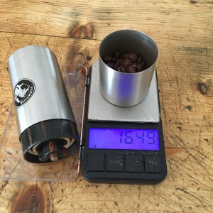
to keep everything together while you’re whirring the grinding arm round. Not to fret – I just weigh the beans in the little cup on the bottom of the grinder, tip them into the top, reattach the cup, grind briskly (it takes me around 3 minutes), take the cup back off (now full of ground coffee), tip the coffee into the Aeropress and <see above>. It’s well made – stainless steel body, ceramic burrs – easy to adjust the fineness of the grind and can be completely dismantled for cleaning.

A nice feature of the grinder is that it slips inside the plunger of the Aeropress, to minimise packed space – I also got the little carrier (the holdall of joy), into which everything fits. To minimise camping/filter paper faffage I got a couple of steel filters from Kofi. One is laughingly tabled fine (it isn’t) and the other mesh (it is). From the Has Bean website, I got a set of compact scales that are accurate to two more decimal places than I require. All packed up in the holdall of joy, it comes to around 700g. I haven’t been backpacking for well over a decade now, but I reckon I could suck that up for the sake of my habit (plus a 250g bag of beans). For car camping, it’s ideal.

IMG_2329

The apple is for scale, it’s not part of my kit. For reference, it’s a medium/small Granny Smith.

So that’s me set up for coffee while camping – I can grind the beans while my terrifying stove boils the water; it’s simultaneously stressful and comforting. I’m thinking about investing in a Staresso, which gets you a bit closer to what you’d make in an espresso machine. It uses some kind of hand pump to develop pressure. What the Aeropress lacks in actual pressure, though, it gains in simplicity. It has one moving part so is pretty difficult to break.

How do you get your coffee fix when you’re away from home?

Note: I bought all this kit myself and have not been in anyway remunerated for this review. Sadly.

Sharp Haw, 21/07/18, 13.5km

The hills:

There’s just the one – Sharp Haw (347m) – on the very southern edge of Yorkshire Dales National Park. It’s the conical summit you can see above Skipton approaching from the bypass. I must have driven past it thousands of times and, until now, have never been up. You can get to this route pretty easily by public transport if you live anywhere in the Aire valley between Skipton and Leeds. I’d normally have a mountain weather forecast here, but look at the date and take a guess about the weather…

The walk:

From Skipton train station, Susan, Harvey and I walk across the carpark and turn right up the main road into town. We head up towards the castle, turn left along onto Mill Bridge, crossing to the north side of the road as we get to the far side of the canal. Chapel Hill draws us northwards up hill. As the lane bears round to the right, we join a footpath

that continues northwards over pasture. We cross a wall over a stone stile at the top and pause for a view of Sharp Haw summit, perched on the horizon like a tiny pap of Glencoe.

IMG_E2293

Like a tiny Pap of Glencoe…

The path drops down past sheep (once again, gentle reader, livestock are not a reliable navigational feature) to the A65 (the A65 is). Do take care here because it can be very busy, though it wasn’t at this juncture. The three of us scarper across the road onto a golf course. The PRoW is marked with yellow capped posts that we follow until we are crossing arable farmland and then a long straight track leading to Brackenley Lane (this is oddly busy with 4x4s as though Embsay is being deserted). Turning left on the tarmac, we follow the road until we reach Grassington Road, which we cross briskly to more sheep pasture.

The footpath takes us due west north west to a much less busy road called Bog Lane. We turn right and then follow the road to the left. When it turns right again, we take a farm track west northwest(ish) across unimproved pasture. As the track bears around towards the west, a footpath runs on across the pasture. We’re onto shallow peat here, dry and dusty after this hot weather. You can practically feel it giving up carbon into the atmosphere as we walk. Around us there are soft rushes, but not much else in the way of real peatland foliage. Perhaps there was a bog here a long time ago.

We veer towards northwest and the path drags us up toward the summit cone. Someone has ambitiously run a a drystone wall across it and, given the gradient, the stile is more of a ladder. Oddly there is also a bench here made from what appears to be stainless steel.

IMG_2298

A much closer tiny Pap of Glencoe.

The view from the summit trig point is tremendous – a brilliant panorama of somewhere I’ve been passing through for most of my adult life but never really stopped to look at. Inevitably, Pendle Hill is lurking off to the southwest in that Lancashire, but we paid it no heed. Airedale and Cravendale is spread out around us.

We stop for some lunch on the north flank, among bilberries, looking northeast across to Rough Haw. You could trot out there and back if you had the time or inclination but we

WQIZ3374

Harvey, smashing gender stereotypes. Photo by Susan.

haven’t so we don’t. Maybe next time. Ever the trailblazer, Harvey smashes gender stereotypes with his pink water bowl.

We drop down the northwest ridge and to our left, the ground is boggier – more rushes and now cottongrass in bloom (though it’s looking a bit knackered). We handrail a wall separating bog and woodland before dropping through a gate and down a hairpin track through commercial forest and rhododendrons. Eventually this comes out next to another stainless steel bench – must be a Skipton thing – where we turn southeast to join a vehicle track running through the pines.

The trees are far enough downhill of us that we have lovely views down the canal and across the vally. The track is sufficiently clear at its sides that enough light is let in to allow flowers, which attract bumblebees.

The track draws us around the contours of the hill, past a big hut with a veranda and some tables and what looks like a generator. No idea what that is, but looks like it should

QJDV1832

Between peat an pines. Photo by Susan.

be selling ice creams. It is not. Damn it. As the path loops around to the east, we drop off the side, through trees and back into rough pasture. Cutting across a dried up stream-bed, we reach walled arable farmland. We hand rail the wall downhill aways until a public footpath takes us back across to Bog Lane, below where we joined it last time. We turn downhill and then take another footpath southeast across pasture to a lane below a static caravan park. Following this south, come out on White Hills Lane, turning southeast and recrossing the A65, this time excitingly (but less dangerously) on a bridge. Again, I’ve been under this bridge an awful lot – it’s oddly thrilling to be on it.


At the far side, where White Hills Lane becomes Raikeswood Road, we turn right into Raikeswood Drive and right again into Rockswood Drive. A vaguely semicircular route takes down through Skipton’s outskirts to Aireville Park where we turn southeast again onto the tarmac track. This draws us over the canal and drops us opposite the station.

Kit List:

In my pack (a Macpac Amp 25): Montane Flux belay jacket, Klättermusen Vidblåin smock, OL Sheet 2, Silva mirror-sighting compass, Benchmade Presidio lock-knife, Highgear AltiTech 2 altimeter, iPhone, Veho Pebble phone-charger, 1.5 litres of water, Terra Nova 2 person emergency shelter, first aid kit, a lot of food. I wore Montane terra trousers, Isobaa Merino 200 zip neck hoodie, Millet Super Trident GTX boots.